 Albuquerque's Environmental Story
Albuquerque's Environmental Story
Albuquerque's Environmental Story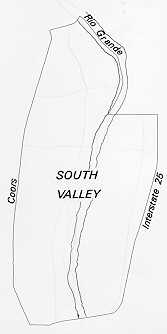 The
South Valley is an area characterized by both urban densities and rural lifestyles.
The northern urbanized neighborhoods near Central Avenue in the Atrisco area
merge into the more semi-urban, and farther south is the open rural ranchos
of Pajarito and Los Padillas The 39 square miles of the South Valley and adjacent
mesa slopes, which comprise more than one-third of the existing metropolitan
area, represents diversity in land use and the rich culture and history.
The
South Valley is an area characterized by both urban densities and rural lifestyles.
The northern urbanized neighborhoods near Central Avenue in the Atrisco area
merge into the more semi-urban, and farther south is the open rural ranchos
of Pajarito and Los Padillas The 39 square miles of the South Valley and adjacent
mesa slopes, which comprise more than one-third of the existing metropolitan
area, represents diversity in land use and the rich culture and history.
The South Valley has clear cultural and ethnic traditions and a very high percentage of residents who, together, have majority ownership rights to most of the land. Its rich history and cultural traditions find expression in place names and in past settlements, first by Pueblo Indians, then by the Spanish and Mexican people.
The history of settlement in the South Valley area began when bands of nomadic hunters and gatherers entered the area at least 12,000 years ago and continues through the periods of Pueblo Indian, Spanish, Mexican, and United States settlement. Archeological evidence indicates that the first pueblo builders entered the valley of the Rio Grande over 600 years ago. The sites of at least five Pueblo Indian community complexes have been identified in the valley area south of Central Avenue and north of Isleta Pueblo.
The first Spanish Expedition to travel through the valley was led by Francisco Vasques Coronado in 1540. In 1598, Juan de Oñate led the first large expedition of settlers north along the Camino Real, the Royal Highway. Some of these expeditions traveled along the east side of the Rio Grande, but many crossed to the west side of the river at Socorro following the route that today is called State Highway 85 and Isleta Boulevard. This route has been described as being the oldest continuously used highway in North America. It was 1600 miles long and accommodated wheeled vehicles as early as 1590. While a number of haciendas and ranchos were established in the South Valley along this route, all were abandoned during the Pueblo Revolt in 1680.
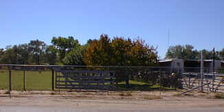 |
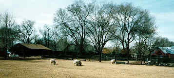
The pattern of land use and settlement found today in the valley began with the land grant communities established during the 1690s and early 1700s, following the reconquest of New Mexico by the Spanish. The early plazas and ranchos of Atrisco, Pajarito, and Los Padillas were established before the town of Albuquerque existed, on land grants issued by the king of Spain to encourage settlement in "New Spain." The land grants of the South Valley were bounded on the west by the Rio Puerco and on the east by the Rio Grande. The narrow valley flood plain along the Rio Grande was ideally suited for irrigation agriculture, which provided the key to survival in this arid region. Each family had access to enough arable land to maintain a largely self-sufficient lifestyle. Over the years, these lands were divided among family members into long strips running perpendicular to the acequias, a pattern still apparent today. The mesa grasslands, held jointly by all members of the community, were used primarily for grazing cattle and sheep.
Since late in the seventeenth century, the South Valley area has evolved from seven small village centers and haciendas surrounded by supporting agricultural lands, marshes, and low sand hills. For over 200 years, families of the area cultivated the narrow strip of arable land between the frequently flooding bosque and shifting sand bars of the Rio Grande, and semi-arid grazing lands that they shared. on the western mesa.
Zebulion Montgomery Pike, one of the first Anglo-American travelers to New Mexico, provides a vivid description of life in the Rio Grande Valley during the early 19th century:
March, 1807
Both above and below Albuquerque, the citizens were beginning to open the canals, to let in the water of the river to fertilize the plains and fields which border its banks on both sides; where we saw men, women, and children of all ages and sexes at the joyful labor which was to crown with rich abundance their future harvest and ensure them plenty for the ensuing year. Those scenes brought to my recollection the bright descriptions given by Savary of the opening of the canals of Egypt. The cultivation of the fields was now commencing and everything appeared to give life and gaiety to the surrounding scenery. We crossed the Rio del Norte, a little below the village of Albuquerque where it was 400 yards wide, but not more than three feet deep and excellent fording.
 |
In 1848, following the Mexican-American War, New Mexico became a territory of the United States. Before this time, land grant boundaries were informally designated by the natural features of the land. During the 1890s, hearings held by the U.S. court of private land claims and the surveyor general confirmed and mapped the land grant claims of the Atrisco, Pajarito, and Los Padillas grants.
In 1880, rail service reaching Albuquerque contributed to the settlement and rapid growth of "New Town." The thriving agricultural communities in the South Valley began exporting sheep, cattle, and a variety of produce throughout the western U.S.
In the 1890s, a bridge was built near Barelas at the river fording site used by the Spanish conquistadors and early settlers. The bridge was rebuilt in 1929, providing a key link in U.S. Highway 85 (Isleta Blvd.). As late as 1931, it was still the longest structure spanning the Rio Grande (1,550 feet). The new span completed in 1984 makes this one of the oldest sites in New Mexico with a bridge continuously spanning the Rio Grande.
During the 20th century, the economic importance of the South Valley communities declined. By 1950, large-scale agribusiness and economic centralization, spurred on by low transportation costs, undercut the economic viability of the South Valley's agricultural base.
 |
Since the sixties, the growth of Albuquerque's population and the desire for low-cost land for residential development has brought increasing pressure on the open areas and agricultural lands in the South Valley. Urban growth began spreading into the South Valley from the north and along its major thoroughfares. Industrial uses were developing along the eastern and western edges of the South Valley. Within the flat flood plain of the river valley, however, agriculture was still the major land use.
Today, with the increasing pressure of development, many agricultural lands in the South Valley are being converted into residential areas. What many people have valued in the South Valley, the agriculture and rural environment, are being sacrificed for development because of the lower land prices. If this trend continues, the farmlands that provide the rural character could be lost forever.
According to the 1990 census, the household income, education levels, and housing values in the South Valley have increased slightly. However when the statistics are compared with those of the rest of the county, the overall percentage is still lower. Complaints about poor roads and street lighting, ground water pollution, lack of job opportunities, and growth pressures are being addressed by Bernalillo County and the community through current projects and those planned for the future.
Too often, the negative aspects are highly publicized, and the many positive features, such as activities and community advocates are not given enough recognition. Despite the negative publicity, many South Valley residents continue to value the beautiful landscape, rural atmosphere, and rich cultural traditions.
(Up to Section II, Back to Southwest Mesa, On to Central Albuquerque)