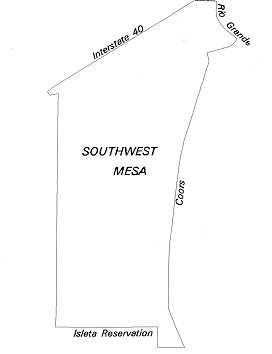
The Southwest Mesa area of Albuquerque is at the western-most edge of development in the metropolitan area. It lies immediately west of the South Valley and south of the Northwest Mesa. The Southwest Mesa is bounded on the north by Central Avenue, on the east by Coors Road, on the south by the Isleta Pueblo boundary, and on the west by the west boundary of Range 2 East (Public Land Survey System).
Existing developed areas on the Southwest Mesa include the Westgate Heights neighborhood and surrounding residential areas, mostly in the northeastern part of the area. There are also a few developed subdivisions within the first mile west of Coors Road that are located south of Westgate Heights. The major linkages of the Southwest Mesa are Coors Road, Bridge Street, Rio Bravo Boulevard, and 98th Street. A new major linkage will be Paseo del Volcan. It will stretch from Interstate 25 (I-25) in or near Bernalillo, through the city of Rio Rancho in the north, and connect to I-40, Central Avenue, and Rio Bravo Boulevard in the Southwest Mesa, and continue to the south and east. The portion from Central Avenue south to Rio Bravo Boulevard has already been built.
The Southwest Mesa area comprises the Ceja (eyebrow) Mesa and the mesa slopes leading up to it. The Ceja Mesa rises from 300 to 400 feet above the Rio Grande flood plain. It is part of an old plains surface through which the Rio Grande once meandered. The Ceja Mesa was once joined to Albuquerque's east mesa before the Rio Grande began cutting the inner valley. Uplifting of the Ceja Mesa, after the river cut the inner valley, gave it 300 feet more in elevation than its mesa counterpart to the east. A fault zone runs along the mesa's eastern edge.
 Terrace
alluvium composed of sands and sandy gravel deposits covers the mesa slope that
begins at Coors Road and extends west to the Ceja Mesa. The slope is cut through
by arroyos, with the Amole Arroyo providing potential open space and trail connections
all the way from the Rio Grande to the Rio Puerco Escarpment.
The semi-arid Southwest Mesa was historically the common grazing land of the families that settled the South Valley. Much of the area was overgrazed, leaving little of the original vegetation indigenous to the West Mesa. Before settlers arrived in the 1600s, the Albuquerque area was the site of continuous occupation for over 12,000 years. The predecessors of the Anasazi were in this area up to 7,000 years ago. The direct ancestors of today's Pueblo peoples were living here as early as 2,000 years ago. More than 30 archaeological sites of lithic scatters, Chacoan outliers, pueblos, and some historic Spanish villages can be found in the Southwest Mesa.
 The
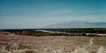
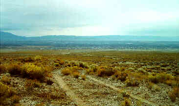
Southwest Mesa landscape is large and open with expansive views of the valley
and Sandia and Monzano Mountains to the east and the far west mesa to the west.
These views are spectacular and should be preserved. Plant life includes cottonwood
and desert willow trees, creosote and juniper bushes, and yucca and prickly
pear cacti, to name just a few. New development in the area should utilize native
and drought-tolerant landscaping (xeriscaping), protect the views, and
strive to enhance and respect the existing conditions.
The
Southwest Mesa landscape is large and open with expansive views of the valley
and Sandia and Monzano Mountains to the east and the far west mesa to the west.
These views are spectacular and should be preserved. Plant life includes cottonwood
and desert willow trees, creosote and juniper bushes, and yucca and prickly
pear cacti, to name just a few. New development in the area should utilize native
and drought-tolerant landscaping (xeriscaping), protect the views, and
strive to enhance and respect the existing conditions.
Today, only a small portion of the Southwest Mesa is developed. The remaining acreage is planned for future development and affords growth opportunities for a range of uses. The Community Identity Program identifies the area as the Southwest Mesa Community. The West Side Strategic Plan has designated four sections in the area including the Bridge/Westgate, Gun Club, Westland South, and Rio Bravo communities. These four communities will be mostly residential with job opportunities in their respective core areas and in the nearby Atrisco Business Park just north of Central Avenue. Strip commercial development will be discouraged in favor of cluster commercial and mixed-use development.
In the past, the Southwest Mesa was important as a travel route between ancient and historical communities and civilizations. The future role of the Southwest Mesa is that of a unique transition zone between the urban areas of the Northwest Mesa, the rural South Valley, and the relatively wild far West Mesa.
* Portions of this article were adapted from Southwest Area Plan, by the Albuquerque and Bernalillo County planning departments (May 1985) and Community Identity Program Final Report, by the City of Albuquerque Planning Department (Feb. 1995).
(Up to Section II, Back to Northwest Mesa, On to South Valley)