 Albuquerque's Environmental Story
Albuquerque's Environmental Story
Albuquerque's Environmental Story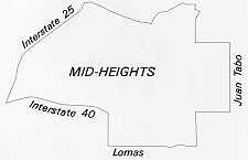 With
the Rio Grande and its overhang as a natural westerly boundary, it was predictable
that Albuquerque's major expansion in the twentieth century would be on the
east mesa, toward the mountains, in what we now call the Northeast Heights.
Particularly from 1950 to 1960, the area's population grew explosively, with
attendant development of many new homes and apartment houses, and the emergence
of Winrock/Coronado as the city's major retailing center. The area of rapid
expansion during the fifties, sixties, and seventies now constitutes the bulk
of the Mid-Heights.
With
the Rio Grande and its overhang as a natural westerly boundary, it was predictable
that Albuquerque's major expansion in the twentieth century would be on the
east mesa, toward the mountains, in what we now call the Northeast Heights.
Particularly from 1950 to 1960, the area's population grew explosively, with
attendant development of many new homes and apartment houses, and the emergence
of Winrock/Coronado as the city's major retailing center. The area of rapid
expansion during the fifties, sixties, and seventies now constitutes the bulk
of the Mid-Heights.
People moved into the area for many reasons. The Mid-Heights offers quick and convenient commuting to government offices, Sandia National Laboratories, the University of New Mexico (UNM), and major employment centers. The city was able to extend water, sewer, roadway and other services from its existing core at reasonable cost. And the developers were able to build attractive new homes that offered low-density living at modest prices for some, and luxurious housing for those willing to pay more to enjoy a blend of privacy, land, and open-space vistas.
The development of the Mid-Heights has, in some ways, paralleled Albuquerque's emergence as one of the fastest growing cities in the Southwest. The brief historical overview that follows reflects some of the significant factors promoting the city's expansion onto the east mesa. These included land speculation, the growth of UNM, and the exploitation, by real estate agents, of the streetcar as a promotional device to sell lots in the suburbs.
The imaginary line that reflected the difference between Old Town and New Albuquerque (New Town) began to dissolve by mid-century, and a new definition of old and new led to a new imaginary line. It was formed beyond UNM, near Carlisle Boulevard. Developers and merchant builders began progressively to shift their housing projects east toward the mountains. Two major determinants for shifting eastward were the price of available land and guaranteed financing. Cheap land made it possible to build at a scale unknown in Albuquerque until the 1950s. Mortgage guarantees provided by the Federal Housing Administration for home buyers significantly reduced the risk of financing residential development.
One of the earliest of the large-scale residential developments was Hoffmantown, located between Pennsylvania and Wyoming, just south of Menaul. Until Hoffman began building in Albuquerque and developed the Bellamah Addition, Hoffmantown, and the Inez Addition, merchant builders had produced residential developments on a small scale. Also, Hoffman brought with him assured financing. These two factors, scale and financing, gave impetus to a new housing boom. With city-owned utilities rapidly extending services to these additions, developers found the economics suitable for building on remote lands. In the four years between 1946 and 1950, the area within the city's boundaries tripled.
Dale Bellamah continued the large-scale development of homes, building the Princess Jeanne Park Addition, Snow Heights Addition, and others.
Expansion of trucking and air freight service during World War II caused freight by rail to decline significantly. And loss of passenger traffic to automobiles and planes had an enormous impact on passenger rail service in New Mexico. Therefore, the military/scientific industry replaced the railroad as Albuquerque's major industry. This new direction in the city's economy began to take shape with the U.S. Army Air Corps in 1940. Kirtland Field expanded during WW II to become a major defense installation, and later Kirtland Air Force Base. With its expansion, Kirtland Air Force Base provided the third essential ingredient for Albuquerque's rapid postwar expansion - the people. From 1940 to 1950, the city's population grew from 35,449 to 96,815, and from 1950 to 1960 it grew from 96,815 to 201,189.
New Mexico became a focal point for atomic research when Los Alamos Laboratory was established in 1943. Much of its equipment and supplies were shipped through Albuquerque because of its excellent air and rail facilities. Kirtland Field, Los Alamos Laboratory, and Trinity Site, all well-known military/scientific facilities, laid the foundations for expansion of the new economic base. The effect of this population explosion of government employees, servicemen, and scientists was a flurry of activity in the housing industry.
Boom Centered in East Heights
Since the military/science industry was centered in the east heights, the housing industry provided housing within quick access along major arterials to Kirtland, Sandia, and Manzano Bases. These major arterials, Louisiana, Wyoming, and Eubank Boulevards, were north-south oriented. They were located one mile apart and formed the major grid transportation network for Albuquerque's east mesa.
By 1950 much of the valley area east of the river between Montaño Road to the north and the extension of Gibson Boulevard on the south was annexed to the city. Much of the east mesa also was annexed during this period. These boundaries of annexation on the east mesa were generally Gibson Boulevard to the south, Tramway Boulevard to the east and Montgomery Boulevard to the north. Several pockets of land were left unincorporated.
During the next period of annexation, 1951 - 1959, many of those unincorporated areas were annexed, completing the area of the Mid-Heights. Although much of the Mid-Heights had been annexed by 1959, the majority of the east mesa from Wyoming Boulevard to the east was not developed and many areas west of Wyoming were still vacant.
Generally, unpaved roads could be found throughout the Albuquerque area. Many of the developed residential areas had access to major arterial streets that were paved, and the majority of interior residential roads were paved in conjunction with development. However, unpaved, and sometimes unplatted, roads still served as quicker access to major arterials.
 |
Commercial development within the Mid-Heights reflects changing trends in retailing. Neighborhood and community shopping areas range from the strip commercial along Wyoming and Menaul to the mixed-use concentrations of the Montgomery/San Mateo and Carlisle/Menaul intersections. The land-use pattern in Albuquerque has shifted from the strip approach to one that concentrates retail activity at key intersections, and these changes are evident in various neighborhoods of the Mid-Heights.
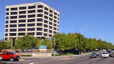
The Uptown area, Albuquerque's largest commercial center, is unique in the urban area, and as a regional urban center, plays a major role in the state. Uptown's borders are roughly between Menaul on the north, I-40 on the south, San Pedro on the west, and Pennsylvania on the east. Uptown is surrounded by residential neighborhoods - Mark Twain on the south, New KiMo on the west, and Inez on the east.
Why is the Uptown area important to the city and how did that area become important? The "why" is easy. The Uptown area is the largest concentration of retail stores currently in the state and contributes both sales tax and property tax dollars to the state and city governments. Sales tax alone brings in over $18 million a year. This area contains more than 2 million square feet of retail stores and draws business to the city of Albuquerque of more than $400 million a year from New Mexico and parts of Colorado, Arizona, Texas, and Mexico. These retail sales and taxes contribute more than the city would normally expect from the same number of retail stores spread throughout the city.
The concentration of commercial activity in the Uptown core resulted from the vision and planning of Dale Bellamah, who in 1954 purchased the land between Louisiana, San Pedro, Menaul, and Indian School for $450,000 from a woman, who had purchased it in 1946 for back taxes of $35,000. Dale Bellamah envisioned the area as a commercial center of hotels, office buildings, and strip retail developments. This concept was still prevalent in 1970 after both Winrock and Coronado Centers were built.
The president of UNM in the late 1950s and early 1960s was Tom Popejoy, who saw the lands owned by UNM as a source of revenue for that institution. Through a personal friendship with Winthrop Rockefeller, a partnership was formed by which the university would lease the land now known as Winrock Center to Winthrop Rockefeller. Rockefeller developed the new phenomenon, a regional shopping mall containing two large department stores and several dozen smaller stores. The university participated in the success of this venture. The department stores which were to anchor the center were J. C. Penney and Montgomery Ward.
During this period, retail stores were having difficulty with downtown locations. Their buildings were old, and repairs by owners were a constant problem. Adequate parking was not available in a booming automobile society. Streets were narrow and driving was restricted. Customer safety was becoming a growing problem, and public and city budgets were stretched to the breaking point. This phenomenon was a nationwide trend. Sears Roebuck was the first to recognize customers' preferences for free parking, control and security, and easier access. Thus shortly after World War II, Sears began to move its stores out of downtown areas. It was during this period that Sears developed into the largest retailer in the US Its competitors did not recognize these customer preferences for more than a decade, and by that time, Sears had achieved an almost insurmountable lead in retail sales. When the competition - J. C. Penney, Montgomery Ward and many individual department stores - finally perceived that customers preferred the outlying stores, suburban development of residential housing was in full development, as was the use of the automobile. Centers like Winrock were the answer to the customers' demands.
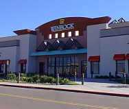 |
Winrock, which totaled more than 500,000 square feet of retail shopping, was completed in 1961. In addition to J. C. Penney, other downtown stores moved in, including Paris Shoes and Stromberg's Inc. Coronado Center, the Homart development, was completed in 1965 and consisted of 450,000 square feet of shopping. Although several other commercial office buildings and residential facilities were constructed, the area was dominated by these two giant shopping centers.
In the seventies, Albuquerque experienced tremendous growth and forecasts predicted more of the same. Retail sales in the country were expanding at a rate equivalent to the country's expanding economy. Several department stores wanted to locate stores in the New Mexico markets, especially Albuquerque. Dillard's and other stores came to Winrock in 1972. In 1976, The Broadway, a California division of the giant Carter, Howley, Hale conglomerate and Goldwater's, the Phoenix, Arizona, division of Associated Dry Goods, another large conglomerate, and enough other stores to more than double Coronado were added.
The shopping centers have continued to evolve as modern concepts of regional malls change. Interior finishes and tenant mix today reflect the national trend to specialty retail, although the centers continue to be anchored by major department stores. The addition of food courts inside the malls and restaurants and movie theaters nearby have enhanced the entertainment possibilities in the area.
The two regional shopping centers continued as the center of retail focus for the state and city. The resulting additional commercial development is a result of the success of these centers. During the 1980s, suburban office buildings filled in vacant land surrounding them. These buildings were taller and more massive than buildings in any other area of Albuquerque except Downtown, and a large number of them incorporated materials and design concepts that were sophisticated by Albuquerque standards. The expansion of Uptown office space and the area's sleek image lured service employment into the Uptown area, increasing its vitality as a mixed-use center.
(Up to Section II, Back to Near Heights, On to North Albuquerque)