 Albuquerque's Environmental Story
Albuquerque's Environmental Story
Albuquerque's Environmental StoryThe geological history that led to the city's familiar mountain/valley/mesa trough shape is long and complex, extending hundreds of millions of years. Its story unfolds as a fascinating scenario involving a series of dramatic earth changes.
 SCENE
I: 1.5 Billion Years Ago
SCENE
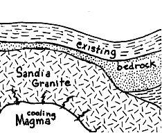
I: 1.5 Billion Years AgoHot, liquid rock (magma) is injected into existing bedrock, cooling and resolidifying
into granite deep below the earth's surface.
No rock layers exist here to tell us of the geological history after the formation
of the Sandia granite and prior to Pennsylvanian times 300 million years ago.
(See SCENE III.) No doubt rock layers were successively deposited but in the
end, the rock was eroded, our area was reduced to a vast, low plain and more
than a billion years of Albuquerque history was thus erased.
 SCENE
III: 300 Million Years Ago
SCENE
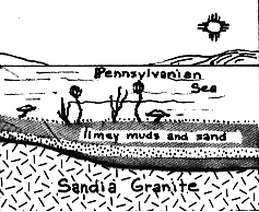
III: 300 Million Years Ago A shallow sea advances into most of New Mexico along great seaways that separate narrow mountainous islands. The uplands erode contributing sand sediments to adjacent seas. Corals, brachiopods, crinoids, and bryozoans inhabit the near-shore waters adding their bodies to the limey sediments, sands and muds accumulating on the floor of the sea.
The Pennsylvania Period takes its name from the geological activity going on
at this time in Pennsylvania: where swamps filled with organic remains eventually
became the coal which made this time period so notable. The symbol "PP"
stands for Pennsylvanian rocks.
 SCENE
IV: 250 Million Years Ago
SCENE
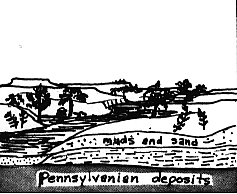
IV: 250 Million Years AgoPennsylvania seas retreat and are evaporated. Muds and sands are deposited by rivers on a vast flood plain inhabited by reptiles and amphibians.
Reptiles dominated by the dinosaurs still rule the earth but wily mammals give
evidence of their mental superiority and adaptability. Deciduous trees. . .
oak, maple. . .become common in the local environments suited to them.
 SCENE
V: 90 to 70 Million Years Ago
SCENE
V: 90 to 70 Million Years AgoAnother major sea advances across New Mexico leaving thick marine shales and
flood plain deposits. Inland from the shoreline of this late Cretaceous sea
lay swamps which locally deposit layers of vegetation in areas which are now
recognized by their coal beds. One such deposit is in the Tijeras Coal Basin.
 SCENE
VI: 25 to 2 Million Years Ago
SCENE
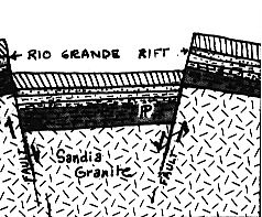
VI: 25 to 2 Million Years AgoGeneralized tension, stretching of the Earth's crust, causes fracturing of
the sedimentary layers and the igneous/metamorphic bedrock. Here in the Albuquerque
area a block of land about 30 miles long between fractures sinks as the blocks
on either side of it undergo uplifting. Thus a huge grave-like trough called
a "rift" is formed. (This rift can be followed for more than 600 miles
from Mexico to northern Colorado.)
 SCENE
VII: Erosion Fills Rift
SCENE
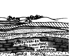
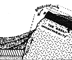
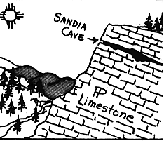
VII: Erosion Fills RiftContinued erosion of the Sandia mountains carries sand and mud westerly down steep arroyos to the rift and down more gentle arroyos and streams to basins on the eastern side of the mountains. Thousands of feet are eroded off Sandia Crest exposing Pennsylvania limestone. The "Great Unconformity" lies beneath it as described in SCENE II.
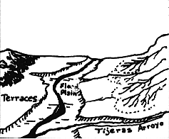
Rio Grande waters soak into deep layers of sands and gravel within the rift.
(People occasionally refer to this as an "underground lake.") Uplift
and changes in stream gradients continues in this region; terraces form as the
Rio Grande erodes and carries materials downstream.
 SCENE
VIII: 150,000 Years Ago
SCENE
VIII: 150,000 Years AgoMagma finds several routes to the surface along a fault line within the rift.
Fluid eruptions contribute flows of magma solidifying into lava; explosive ejections
add scoria and cinders.
 SCENE
IX: Within Last 100,000 Years
SCENE
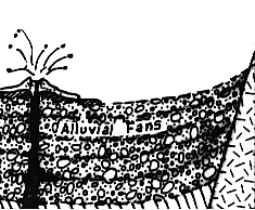
IX: Within Last 100,000 YearsThe Rio Grande follows the rift zone depositing on its flood plain materials which add to the fertility of the alluvial materials eroded from the mountains.
Alluvial fans composed of sands, muds, limestone bits and decomposed volcanic
material and granite form within the rift, one on top of another.
 SCENE
X: 12,000 Years Ago
SCENE
X: 12,000 Years AgoSandia Cave, previously dissolved out of Pennsylvanian limestone as the Sandia
mountains were uplifted, is occupied by one of the earliest known Indian cultures
in North America. The bones of mastodon, mammoth, camels, and bison are left
within the cave. These animals were possibly killed with stone-tipped lances.
(Up to Section I, Back to Back to Climate and Weather, On to On to Geology and Geological History)