 Albuquerque's Environmental Story
Albuquerque's Environmental Story
Albuquerque's Environmental StoryThe physiography of Albuquerque is controlled by a diverse group of geologic features, each with a unique origin. Most of the high mountain country lies along a north-south line which bisects the state. This physiographic demarcation is formed by the Rio Grande Rift, a great fracture in the earth's surface which extends more than 450 miles from Leadville, Colo., to Las Cruces, N.M. The Rift was formed by down-dropping of a large block of the earth's crust, yielding an elongated trough bounded on either side by mountains. The fractures in the crust along which this downward motion occurred are called faults, and many small earthquakes along these faults tell us that the Rift is still actively evolving. These faults are important pipelines for rising heat from the hot interior of the earth. This heat is transported by liquid rock, called magma, which produces volcanoes at the surface along the edges of the Rift, and by heated fluids, which produce hot springs and other manifestations of geothermal energy along the Rift margins. This down-dropped block also provides a low spot in the topography for streams and rivers to flow, such as the Rio Grande, which follows the Rift from Del Norte, Colo., to Las Cruces.
Albuquerque lies in the central part of the Rio Grande Rift. The faulted western margin of the Rift lies along the Rio Puerco, approximately 20 miles west of the Civic Center. The eastern edge of the rift lies at the base of the Sandia Mountains.
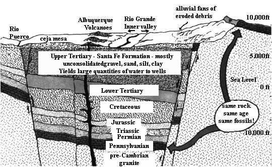 |
The most impressive feature in the Albuquerque area is the lofty mountain range which flanks the eastern city limits. The Sandia Mountains are a great block of granite and limestone which was uplifted during the formation of the Rio Grande Rift. The rise of this immense fragment of the earth's crust is somewhat analogous to opening a trap door; the open door is marked by the gently sloping eastern side of the Sandias, whereas the hinge is found in the intensely crumpled rocks of the Cedar Crest area. The light-colored granite which makes up the majority of the rock in the Sandia Mountains was formed from a magma which solidified one and one-half billion years ago. About 300 million years ago this granite was covered by limey material deposited in an ocean that spread across much of New Mexico. This lime hardened and became the well-layered, fossil-bearing limestone that caps the Sandia Mountains. It was not until relatively recently, about seven to ten million years ago, that the great fault along the western edge of the Sandias began to move, and the Sandias slowly rose to their present commanding height. The total vertical movement on this fault probably exceeds five miles. The same rocks that we see on Sandia Crest lie buried beneath Albuquerque about 15,000 feet below sea level!
Turning to the valley of the Rio Grande, we see the effects of the subsidence of the huge crystal block west of the Sandias. Most of Albuquerque lies on an apron of material that has been eroded from the mountains surrounding the Rift zone and deposited within it. Many thousands of feet of sediment have consolidated to form the underpinnings of the city. We are particularly fortunate that this material is porous, for great quantities of water are stored in the soft sediments of the Rift valley . . .
Below Mount Taylor in the western vistas near Albuquerque are the West Mesa and the Albuquerque volcanoes. The West Mesa, or Llano de Albuquerque, is a remnant of the broad floor of the Rio Grande Rift which developed about 600,000 years ago. This smooth surface formed during a time when there was little movement along the Rio Grande Rift in the Albuquerque area. This surface is now more than 400 feet above the present flood plain of the Rio Grande; thus either the West Mesa has been uplifted or the Rio Grande Rift has subsided in its central part in the last 600,000 years. This is a significant amount of movement for such a short period of geologic time.
The Albuquerque volcanoes are younger than other local volcanoes, forming about 190,000 years ago along a fracture zone within the Rio Grande Rift. This fracture is well-defined by the alignment of the five volcanoes in a north-south direction.
The physiography of the Albuquerque area is thus the sum of many geologic features. The grand design is determined by the Rio Grand Rift, one of the most impressive rift zones on earth. The Rift has fractured the earth's crust and caused the mountainous margins to rise thousands or tens of thousands of feet relative to the subsiding inner valley. As the fractures developed, they acted as conduits for rising magma which produced the volcanic land forms which border the city. These magmas brought with them mineral resources and heat energy. Erosion of the flanking mountains has slowly filled the rift valley with thousands of feet of porous sediment, and with time this sediment has soaked up rain and river water to become a huge underground reservoir. Thus Albuquerque has been blessed with both scenic and natural resources in abundance; it is a perfect place to spend a moment or a lifetime.
*The above material was abstracted from an article, "Grand Designs: A Mini Lesson in Local Geology" by Professor Jon Callender (Albuquerque Magazine, 1978, Vol. 3, No. 1, p. 32-41), and reprinted with the permission of the author.
"The natural and civilized worlds must live together or perish separately."
Henry David Thoreau
(Up to Section I, Back to A Pictorial History of Albuquerque Area Geology, On to Did You Know...)