 Albuquerque's Environmental Story
Albuquerque's Environmental Story
Albuquerque's Environmental Story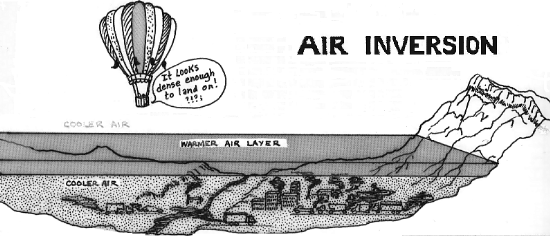 The
Sandias represent a broken segment of the almost continuous Rocky Mountain chain
extending the length of the continent from north to south. They obstruct the
atmospheric flow that exerts a strong influence on the local weather of the
Central Rio Grande Valley. Many polar air outbreaks from the east are steered
away from the city (although they occasionally "leak" through Tijeras
Canyon). Humid summer air from the Great Plains and thunderstorm-spawned tornadoes
are usually kept away by the nearly mile-high mountain barrier. Summer showers
frequently cluster along the mountains as moist air is carried aloft by air
currents rising from sun-heated slopes, thus doubling or tripling the average
annual precipitation received in the adjacent valley.
The
Sandias represent a broken segment of the almost continuous Rocky Mountain chain
extending the length of the continent from north to south. They obstruct the
atmospheric flow that exerts a strong influence on the local weather of the
Central Rio Grande Valley. Many polar air outbreaks from the east are steered
away from the city (although they occasionally "leak" through Tijeras
Canyon). Humid summer air from the Great Plains and thunderstorm-spawned tornadoes
are usually kept away by the nearly mile-high mountain barrier. Summer showers
frequently cluster along the mountains as moist air is carried aloft by air
currents rising from sun-heated slopes, thus doubling or tripling the average
annual precipitation received in the adjacent valley.
Albuquerque's low average humidity, little cloud cover, and valley location encourage formation of significant atmospheric stable layers or temperature inversion. Normally during the day, air temperature decreases with altitude, but after a clear, calm night, "tile air" next to the ground becomes cooler than the air above, forming an inversion. The stable layer suppresses vertical mixing, keeping pollutants (mostly from automobiles) trapped near the ground. This condition can cause episodes of unacceptably large concentrations of pollutants.
(Up to Section I, Back to What Lies Ahead?, On to A Pictorial History of Albuquerque Area Geology)