 Albuquerque's Environmental Story
Albuquerque's Environmental Story
Albuquerque's Environmental StoryMost of us notice with renewed delight each day the grandeur of the Sandia Mountain backdrop to the east, the dramatic volcanoes to the west, and the breathtaking expanse of the Rio Grande Basin between the two. Few of us, however, are aware of the sub-regions and the mini-environments we move across while traveling around the city. We seldom relate the uphill-downhill terrain to the mesas, alluvial fans, inner valley, terraces, flood plain, arroyos, and mountain uplands and lowlands on which the city is constructed.
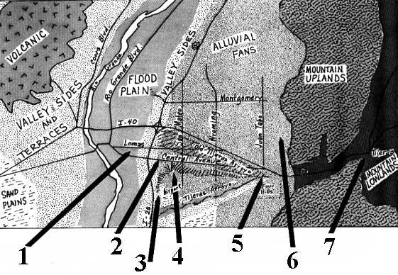 |
If we could turn the clock back thousands of years and strip the signs of civilization from the city's surface, all the natural features would be visible. Although we can't perform these miracles, we can use our knowledge of the city's geology to "look" below the roads and buildings to the land formations underlying them.
"At San Mateo the bear goes underground, there are several
fast-food restaurants right on top of it....
'Do you know where Bear Canyon is?' I asked the clerk. 'Somewhere up by the
mountains,' she said. 'You go up Academy a couple of lights, I think.' Twenty
feet under her, forgotten by the city, lurked the bear."
Tom Harmon, "Ditchbank Chronicles", Albuquerque Journal, March 17, 1984
(Up to Section I, Back to Did You Know, On to Mini-Environments)