 Albuquerque's Environmental Story
Albuquerque's Environmental Story
Albuquerque's Environmental Story  |
The two mountain schools and the APS Outdoor Education Center are the only schools in the Albuquerque system located outside of the Rio Grande Rift. They are situated on the easterly-dipped slope of the Sandia-Manzano uplift, a fault block which defines the easterly edge of the rift zone. The schools are located in pinon-juniper woodland. Taller, denser vegetation, seen uphill from the school grounds, attests to the greater rainfall received in the higher elevations of the mountains. The drainage canyons also have taller, greener, more lush growth due to greater total moisture (precipitation plus runoff).
It is common in the Sandias to see differing vegetation on the two sides of a canyon: tall firs, ponderosa, and spruce on the northern-facing slopes, shorter pinions, junipers, scrub oak, and cactus on the hotter, drier, and environmentally more fragile southern exposure of the same canyon. Two children in the same class, living only a very short distance from each other, might observe very different habitats outside their homes.
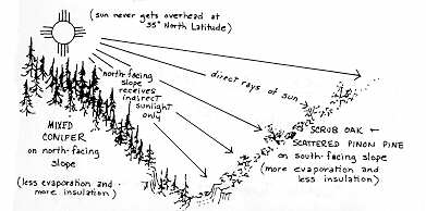 |
Two Microclimates in a Mountain Canyon |
Roosevelt A. Montoya School in Tijeras and San Antonito Sandia Park are both located in areas which are local depositories of mud and gravel recently eroded from surrounding uplands. (On a geological map each location is labeled as a "Q-a," or Quaternary [recent] alluvial material.) In eroding rock layers not far from mountain school playgrounds, direct evidence can be found that ancient environments were vastly different from today's. Roosevelt A. Montoya is located close to a very thick, fossiliferous layer of limestone precipitated out of an ancient sea inhabited by brachiopods, crinoids, bryozoans, and corals some 300 million years ago. (Ideal Cement Company quarries this limestone for its in- dustrial purposes.) Seams of coal near Tijeras were formed millions of years ago from vegetation in a steaming swamp environment. Within the red Abo formation of Tijeras and Sandia Park may be found reptile tracks and plant fossils from a humid, warm, non-marine environment which deposited iron rich muds and sands on a vast river floodplain. Looking at the cross-bedding within some sandstone deposits, geologists tell us of dunes of clean sand swept over large areas by strong, persistent Sandia winds. A gypsum quarry three miles south of San Antonito on the east side of Route 13 makes us aware that the particular area was once a salty lake which evaporated and precipitated layers of gypsum salts. It is difficult for us today to imagine these New Mexico environments so vastly different from the one that man, so recently on the scene, has experienced. But, the evidence is here--in the rocks! At schools located within the Rio Grande Rift (the other 98% of Albuquerque's schools) it would be necessary to drill from 2 to 4 miles (3 to 6 km.) into the earth to find the same bedrock evidence of the geological history of the Albuquerque area. Children in the mountain schools need only look around them.
(Up to Section IV, Back to A Heights School, On to A Cultural Profile)