"The Rio Grande is a linear oasis traversing a semi-desert metropolis . . . an exotic river . . . the river itself meanders between levees approximately 2,000 feet (610 m.) apart. A large length of the river's edge in the west-central portion of the metropolitan area is a low bluff rather than a levee. On the landward side of the levee is a deep drain flowing full with returned water. The riverside drain and levee are like a moat protecting a castle from invaders."
-- City Edges Study.
The Rio Grande is suitably named the "Great River." It is 1,878 miles long, extending from the foot of Stony Pass in the San Juan Mountains of Colorado to the Gulf of Mexico. In North America, it is second only in length to the Mississippi/Missouri combination.
In the Albuquerque region, the Rio Grande is a slow-moving turbid stream. Much of the channel is less than one foot deep, and the water temperature is high during the warm season. The bottom is fine sand and silt. The river channel is of marginal value to most aquatic species due to high turbidity, lack of light penetration for aquatic plants, and the high temperatures.
Shore and wading birds and some waterfowl utilize mud flats and open water. Emergent plants such as bulrushes, sedges, and cattails grow on the margins of the channel.
A network of drains and irrigations canals are distributed throughout the valley. These are maintained periodically by the Middle Rio Grande Conservancy District. Irrigation ditches are dry from October to March, but the drain system has water all year.
Drains and canals are usually lower in turbidity than the river, and a variety of aquatic plants such as algae, bulrushes, sedges, duckweed, milfoil, and stonewort may become established. When ditches are not maintained, they develop marsh-like conditions with good diversity and productivity.
The marsh vegetation -- cattail, bullrush, sedges, watercress and algae -- and the surrounding cottonwoods, provide food, cover and breeding habitat for waterfowl, amphibians, beaver, muskrat, and a variety of songbirds.
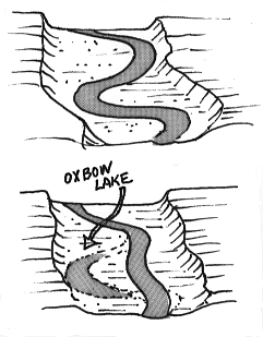
A 37 acre cattail marsh, the "Oxbow," formed at the outfall of the Corrales Drain, is an elbow on the west side of the river
.
Oxbow lakes are remnants of a stram's previous meanderings. When it shifts its course, the meander is cut off, creating a small "oxbow" lake.
(Up to Section I, Back to Valley Sides and Terraces, On to Valley Flood Plains)