 Albuquerque's Environmental Story
Educating For a Sustainable Community
Albuquerque's Natural Environment
Mountain Lowlands
- TERRAIN - Nearly level, but often rugged canyon floors with steep
sides (to 80% slope). Tijeras Canyon grades SW at 1-2% and locally broadens
to an intermontane basin.
- CLIMATE AND AIR QUALITY - Description: climate is transitional
from sub humid to semi-arid. 12-18 inches (30-40 cm.) of precipitation per
year; mean annual air temperature 43-55% (6- 13C), frost-free season 130 to
160 days. Comments: cold air drainage, heavy snow drifts.
- GEOLOGY - West face is nearly all granite; south slope shows various
metamorphics; eastern lowlands covered with limestone, shale. Numerous limestone
outcrops. Resources and hazards: limestone (for a cement plant), shale
(for a brick company), gold, fluorspar, and galena mined in past. Hazards
include landslides and flash flooding.
- SOILS - Association: Seis-Orthida. Description: well
drained stony loams over clayey subsoil, forming from bedrock on nearly level
to steep slopes. Notable Characteristics: severe restrictions to engineering
activities due to slope and bedrock on steer slope; moderate limitations where
grade is less than 15% (these usually are existing slopes).
- HYDROLOGY - Structurally controlled trellis drainage pattern; larger
flat bottomed canyons fed by steep, parallel canyons, in turn fed by small
coalescing gullies. Streams carry snowbelt, sprint-flow, storm runoff; larger
water courses such as Tijeras Creek are virtually perennial. Most flow infiltrates
to stream alluvium or limestone aquifers.
Some local water use from shallow wells; water is available in sufficient
quantities for domestic purposes in most areas, but is hard and has high iron
content in Tijeras area.
- VEGETATION - Zone: Transition (plateau lands). Indicator
Species: some ponderosa pine but mainly pinon pine, junipers mountain
mahogany, sumac and mid and short grasses; also cholla and prickly pear cactus.
Productivity; Sensitivity: less moist than upland areas and therefore
productivity is limited. Some browsing, grazing, and fruit and nut picking
occurs; area is easily disturbed and recovers slowly.
- WILDLIFE - Indicator Species: mule deer, rock squirrel, pinon
mouse, pinon jay, skunks, rattlesnakes, fence lizards. Value: important
wintering area for mule deer and mountain birds; provides food and cover for
some prairie animals.
 Remains
of the mammoth have been found in Sandia Cave and gravel pits within the City
limits.
Remains
of the mammoth have been found in Sandia Cave and gravel pits within the City
limits.
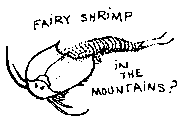 In 1972 after
an especially heavy downpour one mountain rancher found the puddle in his wheat
field teeming with wriggling freshwater shrimp. Eggs lying dormant for decades
had been triggered to hatch and within anew short weeks their life cycle was
completed. This phenomenon is believed to date from ancient times when the area
was covered by a lake. As the climate became drier the shrimp slowly adjusted
their way of life to the dwindling water supply.
In 1972 after
an especially heavy downpour one mountain rancher found the puddle in his wheat
field teeming with wriggling freshwater shrimp. Eggs lying dormant for decades
had been triggered to hatch and within anew short weeks their life cycle was
completed. This phenomenon is believed to date from ancient times when the area
was covered by a lake. As the climate became drier the shrimp slowly adjusted
their way of life to the dwindling water supply.
(Up to Section I, Back to
Mountain Uplands, On to Alluvial Fans)
Copyright © 2008, Friends of Albuquerque's Environmental Story